CENTRAL COLORADO SLOPE FLYING SITES
This page was last updated on Dec. 18th, 2011; thanks for visiting!
(Please be patient while all of the photos of these sites load.
The newest photos added (closer to the end of this page) are of slope combat flying action at the "Dinosaur" and "South Slope" flying sites in Northern Summit County, East off Colorado Highy 9 just to the North of Green Mountain Reservoir , accessed on William's Peak road heading to the east. Click here to jump directly to these photos.)
UPDATE: Click Here to jump down to view three new photos taken from high on the Kenosha Pass south facing slopes, which were taken on March 5th, 2005.
CLICK HERE to visit the VIKING page.
SLOPE FLYING SITE SUMMARIES & LINKS
Click on each of the small images on this page below, to view the larger versions of these photos; use your web browser's "BACK" button to return here.)

Above: my SR HOBBIES "BD5", BOWMAN HOBBIES "JW", and TRICK RC "ZAGI 3C"
For more information on some of my favorite EPP true Slope Ships, please click here to visit the "SLOPERS" page. This page also now includes information on my newest design, the VIKING 60.

WIND FORCAST
Do you wonder what the flying conditions will be like as far as wind direction & strength for the next couple of days? Here's the place to check to get an idea if you'll be likely to lazily float around the slope with your 'floater', or whether you'll need to tie your hat on & pile in the ballast weight in a sleeker slope ship.
HERE'S THE BEST FLYING WEATHER / WIND INFORMATION!! FOR THE SOUTH PARK REGION!: CLICK HERE for Surface Condition Weather Forecasting for Air Sports Aviators: For Leadville, CO
[NOTE: These INTELLICAST maps will give you a good idea of wind direction, but generally, for the South Park region, winds will be stronger than what the map displays.]
LOCAL WEATHER INFORMATION

The National Weather service's closest weather data collection point relevant to the South Park area is located just across the Mosquito Range to the Northwest at Copper Mountain, Colorado. Click on the banner above for local and regional weather information.
SOUTH PARK SLOPE FLYING SITES
[With the north shore of Antero Reservoir being closed for an indefinitely long time since the draining of that reservoir, this is one of the flyable slopes with a S-SW orientation. The other slope flying area that generally faces south is the south side of Kenosha Pass; there again, you need to walk up from the highway to get to the best lift-producing areas. But this new area is well away from the highway, with incredible views across South Park. It's a fantasticly beautiful place to spend some time playing in the winds!]
KING
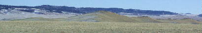
Above photo is the view of the "KING" slope flying site as vieved on 12-01-2001, looking south-east from Park County road 15, as seen just 1 mile east of U.S. Hwy. 285. (Access info follows.) You'll need to scroll right in your web browser window to view the rest of this panoramic view- it's a wide view!
UPDATE: Due to the sale of 160 acres of land to Park County (for the purpose of constructing a shooting range) the access to KING was closed off during the summer of 2011. The KING slope ridge where we have flown in the past is NOT part of the property which was sold, but the access passes through the property which was sold.
I've moved this site to the top of this page because it's the slope flying site in South Park that's most accessible throughout most of the winter, as well as in summer. In this area out in the middle of South Park, there is rarely enough snow accumulation to keep us from being able to drive in to this flying site. I've been out there several times so far in the winter of 2003-2004 on the warmer days. KING is the northern end of a geologic ridge structure, which extends for many miles as a roughly North-South ridge down the middle of the South Park basin. It's most suitable for flying winds coming from the west to the West-Southwest.
[Note on winter accesses: The Mexican Ridge area has the same wind direction orientation, and can be accessible most of the winter, too.... but you need to leave your vehicle on the road and walk up onto the ridge from there to fly, as the actual slopes are on the private lands.]
There is a steep slope about 3/4 miles farther south on the KING ridge structure which produces good slope lift with ~west winds, accessible off Elkhorn road into what's known as Park Gulch on thre topo maps. Snow will block this access in winter, but a 4WD vehicle can access this area from the east side when snow is not an issue, After passing the fire house & bearing to the right to stay on Elkhorn road, you cross through one dip & then come to a cattle guard on the top of the next hill. Watch carefully fopr traces of an old two-track road leaving Elkhorn road to the right just after the cattle guard- it's not too obvious, & the old sign was down on the ground several years ago. Follow the two track back towards the King ridge; you'll pass through two wire gates. Be sure to close these gates after passing through each of them.
[The Hoosier Pass site access road is also snowed in early in the winter, & holds snow blocking the road until sometime well into June on a typical year. The best slope there is most flyable when the winds are coming from the Southeast to East.]
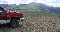
Below: View from KING to the north towards the Boreas Pass section of the Mosquito Range, as viewed form another fine slope flying site in South Park: above the old King Coal Mine site. Photo taken April 1st, 2001, with my modified ZAGI 400 Electric resting between flights in the foreground.

[3] **** Westerly Winds: The King Coal Mine Ridge: 2WD access most of the year. Accessed on the right side of Elkhorn Road (Park County Rd. 15) 1.5 miles east of HWy 285. This site is on open range ranch land, with no fences, gates, or signs. Please respect landowner's rights, and leave no trace when using this (or any other) slope flying site. I've flown here in mid-winter many times, with minimal snow in pockets on the road going in to the ridge.
As you drive east on Elkhorn road, you'll cross a cattle guard about 1.25 miles from Hwy. 285, watch for a two track gravel / dirt road heading to your right about another 1/4 mile past the cattle guard. Take the first fork to the left once you're on the dirt two-track, which will take you around a low ridge to where you're looking at the high point on the KING ridge. You will pass a two-track going off to the east, then come to a place where tracks can bw seen going off to the left, up onto the King ridge. I follow this route to get up onto the launching / landing shelf very close to the top of King, and fly from there- there's enough area to land on the shelf.
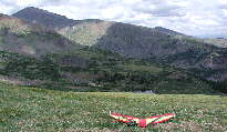
If you were to stay on the lower dirt road, it would take you across the lower west slope of KING, about 1/3 of the way up from the bottom. The King slope is Roughly 250+ foot high slope, relative to the Park Gulch floor below.

The photo above shows me ready to launch the JW close to the top of the main KING slope on 12-01-2001. Lower height slope structure extends to the south for well over another mile, merging eventually into the Mexican Ridge slope structure mentioned elsewhere (above) on this page.
UPDATES: 05-03-2004
So what do you do when you drive all the way into South Park to fly your slope planes, and you get to KING, and find the winds aren't from trhe right direction? Here are two new slopes that I've flown this year that offer different primary wind orientations: more options!
Southwest to South winds option, for access during the times of the year when snow isn't on the ground: West out of Jefferson is a site I've mentioned briefly above, which I flew on January 1st of 2004; shortly after that, snow accumulated & I haven't had a south or southwest wind day to fly since the snow has melted out this spring. When time allows, I'll be working on completing the road log and adding photos of this site. For now, I'll offer this brief information- it'll get you into the area.
You access what I'll refer to as the "KENOSHA WEST" slope site by first heading west off Hwy. 285 in the middle of Jefferson, and follow signs to go towards Jefferson Lake. When you come to the entrance gate to Jefferson lake, you turn right just before the attendant building, onto a dirt road (4WD / higher clearance recommended) and follow the roads back past private ranch land, onto National Forrest land, proceeding to the north & then bearing east from there, to eventually get to the two S & SW facing slopes. (You will drive across a small creek at one point & head on east from there to get to where you want to end up.) You need to park below and hike up to launch & fly on either of these two sites. The Colorado Trail crosses the site that's taller, more open, and to the east of the first slope, so there's a good access trail to get you up onto the shelf. From a distance, it looks like there's fairly good landing conditions up on the shelf, too, so it does look like it's well worththe gradual hike up the good trail.
If the winds are coming more from the NORTHWEST to North- Northwest, right down the spine of King, there are two options within a moderate drive distance, both of which should be accessible most of the winter.
NW to NNW Winds Option: with winds close to coming from West and especially from more NW and NNW, you can either walk up from the road to fly the face on the north end of Mexican Ridge (which is a narrower area of lift, but quite flyable) or you can go to a new site I've located which is nearby :
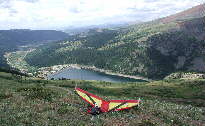
LOOKOUT POINT

NEW PHOTOS added May 3rd, 2004!
LOOKOUT POINT is a slope which is accessible by a road that goes to it's top... which is sometimes nicer than walking up from the bottom! We're not always able to find slope flying sites with the perfect wind exposure that have a road to the top, so it's nice when we do find one :>)

The Lookout Point slope is located to the east of KING and Mexican Ridge, on the western face of the Indian Hills; above is a photo from the parking area at the top of the slope, looking back west towards Mexican Ridge. [ The slope plane is my Viking 60, with the sloper nose taped in place with nylon filament tape.] This is not as wide a slope structure as Mexican Ridge or King, but it is high off the valley floor, and it offers the opportunity to fly winds coming from the NW and NNW, as well as from the West. (With the Antero Reservoir accesses closed at this time, this is the primary flying site I know of for flying NW / NNW winds.)
There are a few smaller aspen and pine trees along the top edge of the slope along the parking area on the NNW side, so I walk down about 50 feet to launch into the winds. With more westerly winds, you could toss a sloper into the air off the edge of the parking area... and likely set your plane back down there, too. (You might want to keep this landing area usage in mind when you decide exactly where to park you vehicle.) You can also land on the slope just off the edge of the parking area. From my flying experience in NW winds on May 2nd, 2004, I'll offer this observation: since the top of this slope is a wider rounded hill, rather than a knife-edge ridge, there is not as much of a problem with rotors being created in the hilltop landing area. If the winds get up over 25 MPH, you might want to re-evaluate this assessment, but in 15MPH winds, landing by circling around the west end of the hilltop to land from the south was not a problem. With moderately strong winds, the lift extended well above the parking area / landing area.
This landing situation is great for dorable aircraft, but might not always be as friendly to built-up balsa planes; the EPP planes will love this site!

Above is a view of the Lookout Point area as viewed from a distance, as photographed from the junction of Elkhorn road and Antler Ridge Road. The parking area on Lookout Point is just below the lower right leg of the star in the photo above. To access this site: From Hwy. 285, go east on Park County Rd. 15 (Elkhorn Road.) 3.5 miles down Elkhorn road, you'll see a red fire station on the left; bear right / south at the fork just past this fire station, staying on Elkhorn Road. At 6.3 miles from Hwy. 285, you'll come to where Antler Ridge Road goes east, to the left; the photo above was taken at that point. Follow Antler ridge road 1.5 miles, until you come to Lookout Road on the left. Another .2 miles or less will put you at the parking area at the top of the LOOKOUT slope site.
Note: (There are no signs which prohibit access at this time, but my map indicates that the Lookout Road and the flying slope of interest might likely not be on public ground- there is BLM ground to the south & below this slope; please keep your vehicle on the roads, and always leave the area in better shape than you found it. (I came away with a bag of litter which I picked up in the area, as I always do whenever I find any... this is just good PR & good manners, and will help us all in keeping a good relationship with the people who own the lands we'd like to continue to use. Just food for thought...)
***** HOOSIER PASS / NORTH STAR MOUNTAIN *****

Click on the small images above, and below, to view the larger versions of these photos; use your web browser's "BACK" button to return here.)
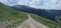
South Winds to Southeast Winds on main slopes; East facing slopes and North facing slopes available too! The photo above is a view of the area as you drive in on the access road, looking at another southeast facing bowl towards the eastern end of this main ridge.
This large slope flying area is located west of the top of Hoosier Pass on Colorado Hwy. 9 between Breckenridge and Fairplay. It is accessed from the parking lot at the top of the pass, along a 4WD / higher clearance vehicle road which is usable only in Summer.
You can drive to the top of a peak overlooking Montgomery Reservoir to the south (as shown in the photo above), launch at close to 12,230 feet elevation, and fly the south (or north) side of this main east-west ridge.
This slope flying site has one of the more spectacular views in the region!
With light winds on the morning of July 4th, 2002 when I shot these photos, I'd hauled out the ZAGI THL shown in the photo above. It's flying at about 13.5 ounces, and does well in light lift conditions. At this light of a wing loading, I could slow it down nicely when the lift died, and keep it up easier than I likely could with the heavier slopers. (The BD5 stayed in the vehicle on this occasion; just not enough wind while I was there.)
I'm using one of the HITEC single stick transmitters & receivers for this ZAGI THL, which has the mixing for the elevons built into the transmitter- a nice feature on a very reasonably priced radio system!
You can land on a reasonable landing area, wide and flat enough for our purposes, on top of this 12,230 lower peak of Northstar mountain. The surface is small rocks; with care, a built-up balsa slope plane can land here. For the EPP slopers, it's more than you would normally ask for! The view shown in the photo above is facing back east along the top, back towards Hoosier Pass, with Silverheels Peak in the distance.
It is also possible to fly this north facing side of the same ridge accessed by the road if winds are coming out of the north. The slope is more gradual on the north side, so the lift is not as good for the heavier EPP slope ships, but it is still very flyable when winds are up from that direction. Quandry Peak, another of Colorado's 14,000+ foot peaks, is the high peak in the background to the left in the photo above.

East winds can be flown on the west side of the area above Montgomery Reservoir , as shown in this photo (taken facing west.) Lincoln, one of five of Colorado's 14,000+ feet peaks in Park County, is shown in the background of the photo above.
It is also possible to optionally fly from the access road at about 12,000 feet elevation, & land on a shelf above the road in the area shown on the left side of the road in the photo above. (This view is facing back east towards Hoosier Pass & Hwy. 9) I'd rate this slope flying area as an Intermediate skill level area. (I have flown my venerable Goldberg Electra in this area before, landing on this shelf above the road.)
If you'll look on page 48 of the DeLorme "Colorado Atlas & Gazetteer", you'll see the road going west up onto part of North Star Mountain. Keep to the left / main fork of the dirt road as you head west; follow it back to a 'pass' that looks north into the Summit County side, and then take the first road there to the right, climbing up back to the east, to the top of the 12,230 feet elevation slope flying site.
ANTERO RESERVOIR NORTH SHORE
UPDATE: Antero Reservoir was re-opened to public access on July 17th, 2007. (You are required to carry a DOW "Habitat Stamp" to use any of the Colorado Division of Wildlife areas in the state - available from any licensing agent for a $10.00 annual fee. ) There are no other fees associated with use of this site.
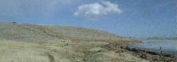
This is a look at the north end of the Antero North Shore Slope; the majority of the SW facing flyable face is actually around the corner on the right. (In the distance to the right are the north facing slopes accessible from the South Shore Access.)
[4]***** Southwest Winds: Antero Reservoir North Shore: 2WD Access Without Snow; novice skill level; top access & landing; water hazzard below.
In the spring of 1999, I flew this site for the first time- one of the slope flying places with the best landing situation I've yet found in the South Park area. This is along the north shoreline of Antero Reservoir, about directly in the top center of the reservoir as viewed on the top of page 70 of the DeLorme "Colorado Atlas & Gazetteer". Access is from U.S. Hwy. 24 just southwest of Hartsel. Drive in through the recrteation access, to the end of the road, and park there. It's a moderately short, level walk to the edge of the slope dropping away to the lakeshore below.
The height of the steep slope is mroughly 160 to 180 feet off the water level below. This typically produces a ridge of lift rising about the same distance above the top edge of the slope. Several things make this an exceptional place for beginning slope soarers to polish their techniques:
[1] The prevailing winds come across several miles of flat water before climbing the nearly 45 degree slope at this edge of the large reservoir, resulting in very laminar, non-turbulent lift.
[2] The slope facing southwest is well over 400 yards wide, providing a wide area of lift, with the primary exposure facing due Southwest.
[3] The landing area extends back behind the hill at the same level as the top of the slope for several hundred feet, with very little or no sage brush or other obstructions, no major rocks- just short grass prarie. This is one of the best landing areas I'm aware of in the mountains, allowing you to simply fly back behind the slope, then turn back into the wind towards the reservoir to land. This is a fine landing area for open structure balsa gliders, unlike the sage brush country prevalent in Summit County to the north of the South Park area.
In weak lift, there would be the possibility of a dunking for non-cautious flyers; there's a narrow margin of lake shore below for landings in some areas along the base of this slope, especially back to the right / north end of the flying slope.
Since this public access is used by fishermen on a year round basis, it should be reasonably accessible to 2WD drive vehicles any time of the year.

North- Northwest- West facing slope on the south side of Antero Reservoir.
ANTERO RESERVOIR SOUTH SHORE
[7] **** North-Northwest Winds to West winds; [also possible to fly east winds on this site]. Acessed from the Antero Reservoir SOUTH SHORE entrance off Hwy 24; [just to the east of the slope mentioned below.] Park along roads close to the entrance to the boat ramp and campground, and walk up from there. This is a wider, steeper, slightly taller slope. The top is wide enough to land EPP foamies on top of this slope. Optionally, you can land below.
Rod Baron, another SPARCS slope flyer, and I walked up and flew this slope in late May of 2002.
There are two flyable slopes, whose main faces are NNW facing and North facing, on the south side of Antero Reservoir, accessed off Hwy. 24 at the access signed as "ANTERO RESERVOIR - SOUTH SHORE". These slopes are on publicly accessable Water Board and State lands. It's OK to walk up to fly these sites- just don't drive off the roads. Park along the shoulder of the roads below.
There are no fences to cross in walking up onto the flyable faces of the west slope (shown in the photo below), and one fence to cross in walking up the slope shown in the photo above. (You'll see a bit of a gulley in the middle of the face; I like to go under the fence in this place.) These slopes are just south of the campground area on the South Shore of Antero Reservoir. The slope is aproximately 200 feet tall or more- I didn't have my GPS along when I took these photos on November 20th, 2001, or when flying here later. I'll hopefully add the GPS coordinates & altitude / height data in the future as flying opportunities allow.

[8] *** North Winds : Acessed from the Antero Reservoir SOUTH SHORE entrance off Hwy. 24; walk up from below: rocky upper slopes, most suitable for EPP Foamies. Balsa structure aircraft might best land below out of the rocks.
North facing slope on the south side of Antero Reservoir.
This slope is just to the right (south) of the slope in the photo above, facing more directly due North. I flew the JW in light winds (~10 to 12 MPH & dieing off) on this slope on 11-20-2001.
MEXICAN RIDGE
[1] ***** West Winds: 265 degree : 2WD Access Without Snow; 4WD in winter recommended; novice skill level; rotor behind knife edge ridge must be avoided! No Sage Brush, few moderate rocks in landing area, ~280 feet parabolic slope rise, 1 mile wide main ridge face south of the road access notch.
These pictures are from several years ago at a part of one of my favorite Slope Flying sites in South Park, "The Basin" between Reinecker Ridge and Mexican Ridge. I've been flying RC planes here in the mountains since the end of 1981, when I started building and flying gliders on slope lift in Summit County.
To get to Mexican ridge, start from US Hwy. 285, just north of the COMO exit; go east on ELKHORN Road (Park County Road 15) for about 10 miles. The location is mapped at the right center of page 49 of the DeLorme "Colorado Atlas & Gazetteer".
Watch for a dirt road on your right, and a sign for "Reinecker Ridge State Wildlife Area". this is "734 Road" . About one mile in off Elkhorn Rd., you'll be passing through the notch on Mexican Ridge, into "The Basin" (Note: Minimal winter maintenance on 734 Rd.; blowing snow can block the road back in about 3/4 mile, but little snow generally falls and stays in this part of south park.
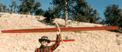
Bruce Stenulson holding a Graupner Cirrus 3 Meter Glider on the west face of the north bowl section of Mexican Ridge
REDHILL RIDGE
[2] ** West Winds: Redhill Ridge: Rough seasonal 4WD Access, or hike up along fence line from near top of Redhill Pass off 285; intermediate to advanced skill level to land above; or fly out & land below.
These next photos are of another slope flying site near the top of Redhill Ridge. Landings on the shelf on higher wind days are more challenging at this site; not quite for novice slope pilots. Optionally, you can land in the flats far below. The panoramic setting is awesome, and there's a resident Redtail hawk that always comes over to check out the strange "bird" in his territory.
The location is mapped just right of center of page 49 of the DeLorme "Colorado Atlas & Gazetteer", which also shows the boundaries of the public lands. Access is by a rather rough 4-wheel drive road going to the south, off the top of Redhill Pass on US Highway 285 just north of Fairplay about 4 miles. About 1-1/2 miles in, you will come to a very noticable line of rocks and boulders, left behind when an aquaduct was burried over the ridge. Follow the two track to the right (west) along the north side of this rock line, up over the ridge and down to the shelf on the west side. The area is on public lands. It is one of the more challenging places to land on the shelf area, and is not recommended for novice slope flyers.

Looking west towards Fairplay and the Mosquito Range from the shelf on Redhill Ridge.
This Slope faces 265 degrees, almost due west.
 This is a view of Redhill Ridge from Hwy. 285 below; the shelf in the photo above is to the right
[5] *** South Winds:

Note: When you click on the small image above to go to the wide panoramic version, you need to scroll right to see the other half of this photo! (Use your web browser's "BACK" button to return here.)
KENOSHA PASS
There are several south facing slopes on the south side of Kenosha Pass, on the west side of US Highway 285, north of Jefferson on the North Edge of South Park.
This is a high slope facing due south- likely only suitable for slope flying when the winds are coming out of that direction. There is a large area, width-wise, that can be flown, and the lift should extend quite a ways above.
In the photo above, you'll notice the tall open slope on the far right, closer to the top of Kenosha pass. This is a more reasonable ~20 to 25 minute walk up from the highway from close to the Historical Monument pullout close to the top of the main grade when driving Eastbound on Hwy. 285. I've walked up from a wide shoulder parking spot along the highway closer to the top of the pass intro a slope which generates great lift. (According to the Pike National Forest map, some of the land above the highway in this area is still private ranch land, along with almost all of the land su\outh of the highway. "Leave only footprints, take only photos!"
Late on the afternoon of March 5th, 2005, I walked up from the highway, carrying the 60" BD5J. As you can see from the photos, landing cross-slope at the top of this slope is possibleble for EPP slope ships, especially if you are set up for spoileron deployment; there's not a lot of area below the aspen grove on the very top, though, that's not part of the lift generating slope, so sidehill landings will likely be the rule on top. The bowl east of the top has areas that would be friendlier for setting down a built-up balsa glider, but there are few really rock-free areas... hey, this is the Rocky Mountains, after all!
The first photo below is taken from a point about 1/3 of the way from where I parked along the highway, looking west towards the top of the first main slope west of the highway. It should give you a fairly good idea of the angle of the slope and of the very large area that's flyable from the top; it also shows more clearly the aspens and Bristlecone pines which are at the very top of the slope. (This was the first day out for the 60" BD5J, and while the winds were stronger in Fairplay when I'd left there, they had died to only a breath of wind by the time I was climbing this slope; but I wanted to check out the top anyway, so I went on up.)

The two photos below show the view from very close to the aspen grove on the top of this slope looking to the South -Southwest across South Park, with the northern Mosquito range in the background; it's an incredible place from which to launch a slope ship, with a lot of sky to fly! I'll definitely plan to be back up there again on days when the wind forecast calls for South winds!


A parting note; the walk up and back down is on some fairly steep slopes in places; a walking stick is certainly not out of the question. I'm thinking of one of those multi-section bungee-corded folding ones made as stream wading staffs that Flyfishermen use, which comes with a belt holster. (Having along a day pack to carry the radio & other stuff also makes sense for the next walk up this slope; it's at least a 20 minute climb up from the highway, so not having the hands too full is really nice.)
Flying lower on the slope, from just below the highway guard rail, will also be a possibility with some slope planes some days; keep in mind, however, that these are private ranch lands, and respect their rights.
SUMMIT COUNTY SLOPE FLYING SITES
If you find yourself in northern Summit County in the Green Mountain Reservoir area, you'll find some very good slope flying possibilities.
Along CO Hwy 9, the area between mile marker 122 and 123 has several pull-offs along the Reservoir side of the road, & good lift in west to southwest wind conditions. There's a wide turnoff area along the highway just south of one of the big cuts through the black shale / coal strata. This pulloff area offers a good place to launch and fly, as well as a reasonable landing area. This is a site with good lift and fairly smooth air. Thher places along the highway / lakeshore may also offer good sloping when the winds are up.
Just north of Green Mountain Reservoir, Williams Peak road heads off uphill to the East; experienced hang gliders fly it from the top, which is 6.5 miles up a sometimes very rocky dirt raod.
The slope combat Fliers of the SUPER 77th fly "Dinosaur"- the ridge on your right as you get up about a mile off the highway on this unimproved dirt road. This tall rocky ridge is ideal for southwest winds.

The photo above shows 12 pilots & spectators in view on the ridgeline on Dinosaur, with 9 slope planes in the air and a guy on the right end ready to fling his plane back into the wind. This photo was taken about 3:15 PM on August 28th, 2005, on the second day of the 2005 Super 77th's Slope Combat Challenge.
"SOUTH SLOPE", Williams Peak

Above is a panoramic view from the access & launching / flying area on William's Peak referred to as "South Slope" (named for the general wind direction orientation of this section of the mountain.) This photo was taken about 7:00 AM on August 28th, 2005, and it looks across the valley towards the Gore Range in the distance, with Green Mountain Reservoir lieing 2400 feet below the flying site.
Below are three photos of the Slope Combat action at South Slope on August 28th, 2005.


Click Here For the latest photos and technical details on my slope flyers, including setup details for Bungee launching.
Return to the RC FLIGHT main page.
Return to Bruce Stenulson's web site Home Page
Web sight designed and maintained by Bruce Stenulson, Fairplay, Colorado. (c) 1997 - 2011; All rights reserved.


